
 deutsche Version
trackmaps
Current light rail trackmap
Complete track network of the KVB in Cologne and surrounding.
Copyright

These drawings are protected by copyright. A further use is possible by application of the Creative-Commons-Lizenz by-nc-sa.
additional maps
current and upcoming projects
-
Linie 13
Verlängerung der Linie 13 ab Sülzgürtel bis zum Rheinufer.
Planung gestoppt | proposed inauguration: noch offen
drawn on the trackmap | website -
Verlängerung Linie 7
Verlängerung der Linie 7 ab Zündorf nach Langel mit Anschluss an die geplante Stadtbahn Bonn – Niederkassel – Köln.
drawn on the trackmap-
Zündorf Süd – Ranzelner Straße: 1. Baustufe
Detailplanung | proposed inauguration: noch offen -
Ranzelner Straße – Langel: 2. Baustufe
Machbarkeitsstudie | proposed inauguration: noch offen
-
-
Mülheimer Brücke
Instandsetzung der Brücke unter Vollsperrung.
in Bau | proposed inauguration: Ende März 2025
drawn on the trackmap | website -
Barbarossaplatz
Bau von Hochbahnsteigen für die Linien 16 und 18 sowie Bau eines Zusatzbahnsteigs für den Karnevalsverkehr.
geplant | proposed inauguration: 2026 -
Mülheimer Süden
Neubaustrecke vom Wiener Platz durch das Stadtentwicklungsgebiet Mülheimer Süden zur Haltestelle Koelnmesse.
Entwurfsplanung | proposed inauguration: noch offen
outlined on the trackmap | website -
Sürth Süd
Neubau einer Haltestelle zwischen Sürth und Godorf.
geplant | proposed inauguration: noch offen -
Haltestellen Gürtel
Neubau von zwei zusätzlichen Haltestellen mit Außenbahnsteigen an den Überführungen Boltensternstraße und Niehler Straße.
Entwurfsplanung Baubeginn frühestens 2027 | proposed inauguration: noch offen | website -
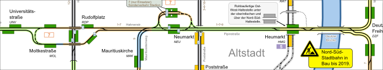
Nord-Süd-Stadtbahn
Neubaustrecke von Breslauer Platz/Hauptbahnhof bis Arnoldshöhe
drawn on the trackmap | website-
Dom/Hbf. - Rathaus: Teilinbetriebnahme der 1. Baustufe
in Betrieb | inauguration: Dezember 2012 -
Rathaus - Heumarkt: Teilinbetriebnahme der 1. Baustufe
in Betrieb | inauguration: Dezember 2013 -
Schönhauser Straße - Severinstraße: Teilinbetriebnahme der 1. & 2. Baustufe
in Betrieb | inauguration: Dezember 2015 -
Heumarkt - Severinstraße: Lückenschluss des 1. Bauabschnitts nach Abschluss der Arbeiten an der Einsturzstelle des Stadtarchives.
in Bau | proposed inauguration: 2028/29 -
Bonner Wall - Arnoldshöhe: 3. Baustufe. Der Abschnitt bis Marktstraße wurde bereits 2008 fertiggestellt, bislang aber nicht in Betrieb genommen.
baulich fertiggestellt Baubeginn: November 2021 | proposed inauguration: Frühjahr 2028 -
Arnoldshöhe - Meschenich: 4. Baustufe
Detailplanung | proposed inauguration: noch offen
-
Short-time construction works with no effect on the trackmap are not listed here.
| network data | |
track gauge: | 1435 mm |
network, total length (2012): | 134,9 |
| Rolling Stock (2012) | |
trams: | 384 |
historic trams: | ~25 |
units needed for regular service: | 155 |
| Remark: Figures regarding the Bonn-section of lines 16 and 18 see at Bonn | |
| partly estimated | |
- 25.11.2024
Plan for the new stop Meschenich added. - 17.05.2024
Reconstruction of Schlebusch stop. - 08.03.2024
Plans für the extension of line 13 added. - 30.05.2023
Proposed stop Sürth Süd added. - 16.04.2023
Plans for the extension of line 7 added. - 10.04.2023
Plans for the reconstrustion of Schlebusch stop added.
Found a mistake?
You've found a mistake in the map or you know a current change? Here you can directly advise it. This will be considered in the next update.
Updates of the maps will be done about every month. You will get a message when the update is done.
Contact form
via e-mail:
gleisplan@web.de