Hannover 
 deutsche Version
trackmaps
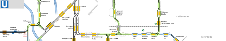
 Hannover Stadtbahn
Copyright

These drawings are protected by copyright. A further use is possible by application of the Creative-Commons-Lizenz by-nc-sa.
additional maps
current and upcoming projects
-
Vahrenheider Markt
2 Verlängerung der Bahnsteige auf 70m
fertiggestellt Umbau Richtung Innenstadt bis Dezember 2025, Gegenrichtung ab Januar 2026 | inauguration: 09.05.2026
drawn on the trackmap | website -
Großer Kolonnenweg
2 Verlängerung der Bahnsteige auf 70m
in Bau | proposed inauguration: Juli 2026 | website -
Reiterstadion
2 Verlängerung der bestehenden Hochbahnsteige auf eine Länge von 70 m in zwei Bauabschnitten.
geplant Baubeginn: 3. Quartal 2026 | proposed inauguration: 2027 | website -
Tempelhofweg
2 Verlängerung der bestehenden Hochbahnsteige auf eine Länge von 70 m in zwei Bauabschnitten.
geplant Baubeginn: 3. Quartal 2026 | proposed inauguration: 2027 | website -
Ludwig-Sievers-Ring
13 Neue Haltestelle mit Mittel-Hochbahnsteig als Ersatz für Bothfelder Kirchweg.
in Bau | proposed inauguration: Ende 2026
drawn on the trackmap | website -
Fasanenkrug
13 Ersatz der Wendeschleife durch eine Stumpfendstelle. Während des Baus wird an einer provisorischen Haltestelle gehalten.
in Bau Baubeginn: 28.04.2025 | proposed inauguration: Anfang 2027
drawn on the trackmap | website -
Langenhagen/Angerstraße
1 Neubau von Seiten-Hochbahnsteigen (70m) südlich der bestehenden Haltestelle.
geplant Baubeginn: 2027 | proposed inauguration: noch offen -
Linden Mitte
9 Bau von Mittel-Hochbahnsteigen an den Haltestellen Am Lindener Hafen und Bernhard-Casper-Straße.
geplant Baubeginn: 2027 | proposed inauguration: noch offen
drawn on the trackmap | website -
Laatzen/Park der Sinne
1 Neubau von Seiten-Hochbahnsteigen (70m) südlich der bestehenden Haltestelle.
geplant Baubeginn: 2027 | proposed inauguration: noch offen -
Kabelkamp
1 Neubau von Seiten-Hochbahnsteigen.
in Bau | proposed inauguration: Sommer 2027
drawn on the trackmap | website -
Windausstraße
1 Neubau von Seiten-Hochbahnsteigen.
Planfeststellungsverfahren | proposed inauguration: Sommer 2027
drawn on the trackmap | website -
Bahnhof Nordstadt
6 Neubau eines Mittel-Hochbahnsteigs
in Bau | proposed inauguration: Ende 2027
drawn on the trackmap | website -
Schulenburger Landstraße
6 Neubau der Eisenbahnbrücke und Ausbau der Stadtbahnstrecke mit besonderem Bahnkörper bis Fenskestraße.
geplant | proposed inauguration: 2028 -
Limmerstraße
10 12 Bau von Mittel-Hochbahnsteigen an den Haltestellen Am Küchengarten, Leinaustraße und Harenberger Straße.
geplant Vollsperrung ab 01.09.2028 | proposed inauguration: 2031
drawn on the trackmap -
Garbsen Mitte
4 Streckenverlängerung ab Garbsen bis Garbsen Mitte mit der Zwischenhaltestelle Auf der Horst / Uranushof.
Entwurfsplanung Baubeginn: frühestens 2029 | proposed inauguration: noch offen
drawn on the trackmap | website -
Arnum
13 Neubaustrecke von Hemmingen nach Arnum mit zwei neuen Haltestellen.
Machbarkeitsstudie | proposed inauguration: 2030
drawn on the trackmap -
Betriebshof Lahe
Neubau eines Betriebshofes für 120 Stadtbahnen nahe der Haltestelle Oldenburger Allee.
Machbarkeitsstudie | proposed inauguration:
drawn on the trackmap
Short-time construction works with no effect on the trackmap are not listed here.
| network data | |
inauguration: | 16.09.1872 |
track gauge: | 1435 mm |
operator: | üstra |
network, total length: | 121,2 km |
| rolling stock (2022) | |
metro cars: | 349 |
thereof TW 6000: | 53 |
thereof TW 2000 / 2500: | 143 |
thereof TW 3000: | 153 |
historic trams: | 8 |
- 29.05.2026
Plans for reconstruction of Limmerstraße added. - 20.12.2025
current change of timetable - 03.05.2025
Begin of reconstruction works at Fasanenkrug. - 04.08.2024
Line 2 extended to Gleidingen. - 08.06.2024
High level platforms Rethen / Pattenser Straße and Gleidingen in operation. - 09.05.2024
New platform Freizeitheim Linden Inaugurated.
Found a mistake?
You have found a mistake in the map or you know a current change? Here you can directly advise it. This will be considered in the next update.
Updates of the maps will be done about every month. You will get a message when the update is done.
via e-mail:
gleisplan@web.de