Duisburg 
 deutsche Version
trackmaps

 Duisburg light rail & tramway
Copyright

These drawings are protected by copyright. A further use is possible by application of the Creative-Commons-Lizenz by-nc-sa.
current and upcoming projects
-
Karl-Lehr-Brückenzug
Neubau und Inbetriebnahme der Brücken über die Ruhr und den Hafenkanal neben den bestehenden Brücken. Später Verschiebung an den endgültigen Standort.
fertiggestellt | inauguration: 26.06.2026
drawn on the trackmap | website -
Kulturstraße
Neubau eines Hochflur-Mittelbahnsteig.
in Bau Baubeginn: 01.06.2026 | proposed inauguration: Ende Oktober 2026
drawn on the trackmap -
Watereck
Erweiterung der Kehranlage
geplant | proposed inauguration: Herbst 2026
drawn on the trackmap -
Grunewald Betriebshof
Ersatz des flachen Mittelbahnsteigs durch einen hochflurigen.
geplant | proposed inauguration: Frühjahr 2027
drawn on the trackmap -
Albertstraße
Ersatz der flachen Seitenbahnsteige durch einen Niederflur-Mittelbahnsteig
geplant | proposed inauguration: 2028
drawn on the trackmap -
Karlstraße
Barrierefreier Ausbau
geplant | proposed inauguration: 2028 -
Marxloh Pollmann
Barrierefreier Ausbau
geplant | proposed inauguration: 2028 -
Wilfriedstraße
Barrierefreier Ausbau
geplant | proposed inauguration: 2028 -
Platanenhof
Neubau von gemischten Nieder- und Hochflur-Seitenbahnsteigen.
geplant | proposed inauguration: 2029
drawn on the trackmap -
Neustraße
Barrierefreier Ausbau
geplant | proposed inauguration: 2029 -
Hamborn Betriebshof
Barrierefreier Ausbau
geplant | proposed inauguration: 2030 -
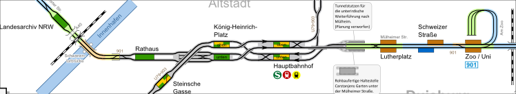
Schweizer Straße
Barrierefreier Ausbau
geplant | proposed inauguration: 2030 -
Fischerstraße
Barrierefreier Ausbau
geplant | proposed inauguration: 2030 -
Ruhrort Bahnhof
Barrierefreier Ausbau und Stilllegung der Haltestelle Friedrichplatz
geplant | proposed inauguration: nach 2030 -
Thyssen Tor 30
Barrierefreier Ausbau
geplant | proposed inauguration: nach 2030
Short-time construction works with no effect on the trackmap are not listed here.
| network data | |
inauguration: | 24.12.1881 |
track gauge: | 1435 mm |
overhead wiring: | 750 VDC |
operator: | Duisburger Verkehrsgesellschaft (DVG) |
network, total length: | 53,3 km |
| (U79 in Duisburg and Mülheim and Dinslaken branches included) | |
| rolling stock (2020) | |
trams: | 38 |
metro cars: | 18 |
maintenance and service vehicle: | 2 |
- 05.07.2026
New Karl Lehr bridge inaugurated. - 13.06.2026
High level platform at Kulturstraße under construction. - 10.11.2025
Plans for the reconstruction of Watereck siding added, reconstruction of Stockumer Straße finished. - 10.06.2024
Reconstructed stop Karl-Jarres-Straße in operation. - 01.06.2024
Plans for the reconstruction of Kulturstraße and Grunewald Betriebshof added. - 23.12.2023
New Oberbürgermeister-Karl-Lehr-Brücke inaugurated.
Found a mistake?
You have found a mistake in the map or you know a current change? Here you can directly advise it. This will be considered in the next update.
Updates of the maps will be done about every month. You will get a message when the update is done.
via e-mail:
gleisplan@web.de