Rostock 
 deutsche Version
trackmaps
 Rostock tramway
Copyright

These drawings are protected by copyright. A further use is possible by application of the Creative-Commons-Lizenz by-nc-sa.
additional maps
current and upcoming projects
-
Neuer Friedhof
3 6 Stilllegung der Wendeschleife durch den Abriss der Brücke über die Bahnhlinie.
geplant | proposed inauguration: Oktober 2026 -
Tram West
3 6 Neubaustrecke von der Haltestelle Zoo durch Gartenstadt und Reutershagen zur Haltestelle Rahstädter Weg.
Entwurfsplanung Baubeginn: 2028 | proposed inauguration: 2031
drawn on the trackmap | website
Short-time construction works with no effect on the trackmap are not listed here.
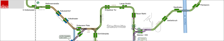
| network data | |
inauguration: | 14.10.1881 |
track gauge: | 1435 mm |
overhead wiring: | 750 VDC |
operator: | RSAG |
network, total length: | 35,6 km |
stops: | 64 |
lines: | 6 |
line length: | 86,4 km |
| rolling stock tramway (2012) | |
trams: | 58 |
historic trams: | 3 |
units needed for regular service: | 37 |
| partly estimated | |
- 13.08.2020
New stops added. - 05.12.2018
Construction work at Petribrücke finished, new platforms at Steintor. - 30.09.2017
New changeover at Petridamm. - 17.08.2017
Track connection Kunsthalle removed. - 04.01.2016
- 15.12.2013
Found a mistake?
You have found a mistake in the map or you know a current change? Here you can directly advise it. This will be considered in the next update.
Updates of the maps will be done about every month. You will get a message when the update is done.
via e-mail:
gleisplan@web.de